Marcel Sanchez-Prieto and Joshua Stein Recognized with 2020 ACSA Project Awards
Woodbury professors Marcel Sanchez-Prieto and Joshua Stein have been recognized by the Association of Collegiate Schools of Architecture with a Best Project Award and Best Project Honorable Mention. Each year, ACSA honors architectural educators for exemplary work in areas such as building design, community collaborations, scholarship, and service. Award winners and honorable mentions inspire and challenge students, contribute to the profession’s knowledge base, and extend their work beyond the borders of academy into practice and the public sector. The two projects will be presented at the ACSA108 Virtual Conference.
.
Best Project | Between Living and Consuming the Territory
Marcel Sanchez-Prieto & Adriana Cuellar | Woodbury University & University of San Diego
Between Living and Consuming the Territory: Apan Social Housing
Apan Social Housing is the Research and Experimentation Laboratory Center for Housing by INFONAVIT (Institute of the National Housing Fund for Workers), located in a reserve owned by the Institute “San Miguel del Arco” in Apan, Hidalgo Mexico. The laboratory center will be used as a meeting point for reflection and improvement of housing financed by INFONAVIT. The project is part of the research “From The territory to the Inhabitant” commission by INFONAVIT among 90 proposals to study rural housing in Mexico, the selected 32 built housing prototypes exemplify an approach for different climatic and cultural needs. The participating proposal is for the community Hindu, a population of 4000 inhabitants located on the outskirts of the city of Tecate, Mexico, mostly engaged in the production of materials made with clay and mud, highlighting pottery, pots and bricks. A marginalized community founded more than 20 years were their economic activities carried out remain similar and continue to lack services such as paving, garbage collection and in some sections lack electricity and drinking water.
Its location is characterized by being among the three municipalities of greatest impact, east with Mexicali the state capital, west with Tijuana one of the cities with greatest economic boom and south with the port of Ensenada, over time the community has remained to some extent isolated from these three cities, both for its lack of interconnectivity and infrastructure at the state level and internationally with the United States, now the Hindu community is under rapid pressure of densification due to its strategic centralization to its neighboring cities. With little separation between living and working areas, the prototype is an approach to contemporary rural territory. This approach includes a change of interest over focuses merely on densification and more on the different parameters that make up the housing, the proposal therefore seeks social interconnection, prioritizing the interstitial space as patios and voids within the territory, what is fundamental is the integration between architecture, nature and infrastructure. It is an evolving housing prototype and even opportunistic in adapting to the growths between family nuclei and their sources of work. The growth components are modules that can be incorporated in any of the sides of the central nucleus. The system expands the factors of FAR Floor area ratio to TAR, Transformation area ratio and PAR Productivity Area Ratio, evaluating and measuring adaptability in coordination with the use of space, the economy of means and resources of family growth. The house takes the conditions of the Hindu community as a perceiver of contemporary and traditional rural ways of life, where the courtyard and the relationship with the territory is of utmost importance, not as an adjacent space but as the central one in which the location of the house is articulated, this close relationship is emphasized as a space that gathers and frames the chores of the family, both domestic and work, between the production of bricks and family ties.
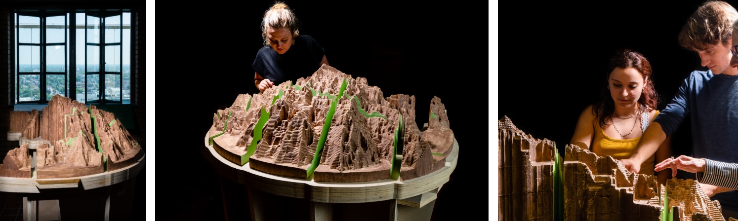
Best Project Honorable Mention | Isochronic Mountains
Joshua Stein | Woodbury University
Isochronic Mountains: Mapping, Modeling, and Materializing Urban Inequities
The Isochronic Mountain project is a series of “landscape” models that offer the public a physical manifestation of the invisible infrastructures and inequities that shape everyday life in their contemporary cities, refiguring and recasting the sprawl of the global city through the historical technique of ceramic casting. These mountains integrate a varied set of architectural tactics to render GIS and demographic data apprehensible and productive inside contemporary debates concerning the right to the city. Specifically, by visualizing time spent on public transit as the z-height, the Isochronic Mountains offer an intuitive understanding of the “uphill climb” necessary to move through the city without a car. Initiated with a comparative study of Sao Paulo’s transit network both past (1939) and present (2013), the resulting Mountains dramatically yet accurately demonstrate the struggle to move through the city by transit. Each landscape reveals the neighborhoods that are infrastructurally underserved, “transit valleys” where the uphill climb to reach the city center is more intense. Viewed comparatively, the geological metaphor also visualizes how this struggle has intensified over the last 75 years due to the “erosion: of transit infrastructure in relationship to the growing urban megalopolis.
The most recent Isochronic Mountain study examines similar issues in Buffalo, NY through a collaboration with local GIS analysts and transit advocates. While the erosion of Buffalo’s once great transit network has had repercussions for the entire city and region, the impact has not been equal across all of the city’s inhabitants. Perhaps most significantly, the demise of the streetcar network, along with other related factors, would help to segregate the city in a structural way that remains in place today. Buffalo’s inhabitants with no access to cars are three times more likely to spend 1.5 hours per day commuting. This translates to significant economic segregation, which reinforces Buffalo’s extreme racial segregation. As public funding shifted from street cars to roads, only a certain portion of the population was able to take advantage of this new infrastructure. According to the “One Region Forward” study by the UB Regional Institute, “across the US, workers who use public transit earn almost as much as workers who drive alone, but in Buffalo Niagara, workers who use public transit earn only half as much as those who drive alone.” * The paper charts the translation of raw GIS data and archival research into a material artifact that expressively conveys the geological metaphor of difficulty and loss while accurately representing the experience of the lived city. *Source: University at Buffalo Regional Institute, State University of New York at Buffalo, School of Architecture and Planning. 2014. “One Region Forward: A New Way to Plan for Buffalo Niagara,” p.68.